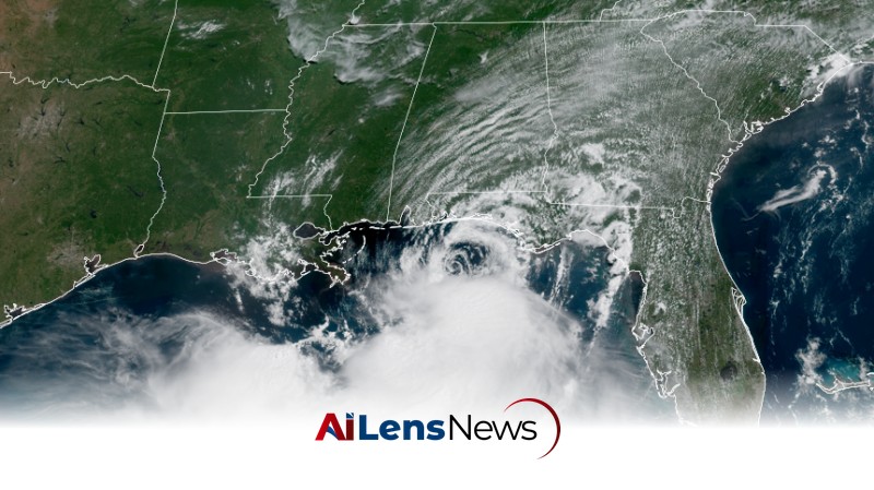


Tropical Storm Bertha is expected to bring heavy rain, gusty winds, and coastal flooding to the Gulf Coast from Florida to Louisiana as it moves westward.
Washington DC, United States Jul 21, 2026 ALN: Tropical Storm Bertha has strengthened in the northeastern Gulf of Mexico, where it is expected to bring periods of rain, gusty winds, and coastal flooding to parts of the Gulf Coast, affecting states from Florida to Louisiana. This development comes as residents prepare for the potential impacts of the storm, which has increased in intensity but remains disorganized in its structure.
As of late Tuesday morning, Bertha's maximum sustained winds have increased from 50 mph to 60 mph. However, meteorologists predict that the storm will experience little change in strength for the remainder of Tuesday. The storm's structure is currently lopsided, with most of its thunderstorms concentrated in the southern half. This is largely due to unfavorable upper-level winds and dry air that continue to disrupt the storm's development, despite the presence of near-record warm waters in the Gulf, which typically serve as fuel for tropical systems.
This uneven distribution of thunderstorms means that much of Bertha's heaviest rain and strongest winds are expected to remain offshore as it slowly moves westward along the northern Gulf Coast through Wednesday. Nonetheless, tropical storm conditions are beginning to spread into the immediate coast of the Florida Panhandle as of Tuesday afternoon, according to the National Hurricane Center. Additionally, the storm is generating bands of rain and rough surf that are impacting parts of the northern Gulf Coast.
Beyond the immediate coastal threats, Bertha's moisture is expected to contribute to a flooding rain threat hundreds of miles away in the Southeast. A cold front stalling in the region will pull moisture from the Gulf, leading to increased rainfall from Wednesday through the end of the week, particularly over the Carolinas and southeastern Virginia. This could exacerbate existing flooding concerns in areas that have already experienced significant rainfall in recent weeks.
Bertha is noteworthy as the second named storm of the Atlantic hurricane season, which has had a slower start compared to recent years. This slower onset is attributed to the influence of El Niño, a climate pattern characterized by warmer ocean temperatures in the central and eastern Pacific, which can have widespread effects on weather patterns in the Atlantic basin. The National Oceanic and Atmospheric Administration (NOAA) has forecasted a lower-than-average number of named systems in the Atlantic this season, largely due to the prevailing conditions associated with El Niño.
The projected track for Bertha indicates that it will likely move along the Gulf Coast and make landfall or graze the southeastern coast of Louisiana by early Wednesday evening as a weak tropical storm. After making landfall, Bertha is forecast to continue tracking toward the Upper Texas Coast while weakening to a tropical depression later in the week. However, there is a possibility that the storm may not progress that far west due to the significant wind shear it is currently encountering.
Wind shear refers to the change in speed or direction of winds at different altitudes in the atmosphere. This phenomenon can disrupt the organization of a storm, literally tearing it apart and preventing it from developing into a more robust system. In the case of Bertha, the wind shear is causing most of its thunderstorms to be displaced south of the storm's center, which limits its overall strength and potential for further intensification.
As Bertha interacts with the land along the Gulf Coast, the conditions will become even more hostile. This interaction will cut off the warm, moist air from the ocean that is crucial for sustaining the storm's development, potentially leading to its dissipation sooner than expected, particularly near the Louisiana coast.
Regardless of the storm's ultimate fate, bands of rain, gusty winds, and some coastal flooding are anticipated to impact the northern Gulf Coast through at least Thursday. A tropical storm warning has been issued for the western Florida Panhandle, coastal Alabama, Mississippi, and far southeastern Louisiana. In these areas, tropical storm conditions, characterized by sustained winds of 39 mph or higher, are expected to develop within the next 36 hours. Tropical storm watches are also in effect as far west as south-central Louisiana, indicating that residents should prepare for the possibility of severe weather.
Here’s what residents can expect from Tropical Storm Bertha:
• Rainfall: Rainfall totals of 1 to 4 inches are forecasted, with localized amounts potentially reaching up to 6 inches in the strongest thunderstorms. This precipitation could lead to flash flooding, particularly in urban areas such as New Orleans, where drainage systems may struggle to cope with the sudden influx of water.
• Wind: Sustained winds of 39 mph or greater are expected in the tropical storm warning area, including the western Florida Panhandle, Alabama, Mississippi, and southeastern Louisiana coasts, from late Tuesday into Wednesday. Higher gusts associated with thunderstorms could result in isolated power outages and downed trees.
• Storm Surge: Coastal residents should prepare for a storm surge that could elevate water levels by 2 to 4 feet above normal from the mouth of the Mississippi River in southeast Louisiana to the Alabama-Florida border. This surge is expected to coincide with high tides on Wednesday and Thursday mornings, leading to moderate coastal flooding in low-lying areas. A coastal flood warning is currently in effect for the southeast Louisiana and Mississippi coasts.
• Dangerous Beach Conditions: The storm is also generating rough surf and creating a high risk of rip currents at beaches from the Florida Panhandle westward to Alabama, Mississippi, and Louisiana. These hazardous conditions are expected to persist through at least Thursday, posing life-threatening risks even to experienced swimmers.
As Tropical Storm Bertha continues to evolve, residents along the Gulf Coast are urged to stay informed through local weather updates and adhere to any advisories or warnings issued by meteorological authorities. Preparedness measures, including securing outdoor items and having emergency supplies ready, are crucial in mitigating the impacts of the storm.
To learn more about the latest developments in Crime & Law, stay updated with our exclusive reports and analyses on AiLensNews.